Mapping And Surveys

WE ARE DRIVEN BY OUR VALUES, PURPOSE AND PROMISE

Drone technology for land surveying has become increasingly popular due to its efficiency, cost-effectiveness, and accuracy. Drones equipped with high-resolution cameras, LiDAR (Light Detection and Ranging) sensors, and GPS receivers can capture detailed images and data of land surfaces, enabling precise mapping and analysis. Here's how the process generally works.
-
Construction: Site surveys, progress monitoring, volume measurements, 3D modeling.
-
Mining and Aggregates: Stockpile volume calculations, site mapping, exploration, environmental monitoring.
-
Agriculture: Crop health monitoring, field drainage assessment, irrigation optimization.
-
Infrastructure Inspection and Maintenance: Bridge, road, railway, pipeline inspections, defect detection.
-
Real Estate and Property Management: Aerial photography, property condition assessment, boundary mapping.
-
Environmental Monitoring and Conservation: Habitat monitoring, wildlife tracking, forestry management, impact assessments.
-
Surveying and Mapping: Aerial imagery, topographic mapping, terrain modeling.
-
Insurance and Risk Assessment: Property damage assessment, claims processing, risk evaluation.
-
Emergency Response and Disaster Management: Search and rescue, damage assessment, situational awareness.
Industries require surveyors to provide maps of land areas. From determining the overall grade of an area to creating detailed maps of each square foot, drone mapping makes the surveyor's job easier, faster, and safer. Among the many industries that use drones for GIS surveying, some of the most important include
Topographic Surveying
Drones greatly reduce the human cost of topographic surveys, making them more efficient and accurate. Survey drones can produce high-resolution orthophotos and detailed 3D models. Even in complex or difficult-to-access environments, they can still produce high-precision maps quickly. Surveyors can use these maps, combined with expertise, to produce extremely accurate maps for their clients.
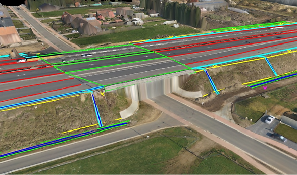
Road construction surveying
A drone in construction helps councils, transport agencies, and civil engineering companies create accurate, large-area linear maps quickly and accurately. By carrying LiDAR, it can measure earthwork and soil precisely.
Dam surveying
The measurement of dams and other large structures can be a challenging task due to varying static water levels and hard-to-reach areas. Combining advanced sensor equipment, flexible communication systems, and compact designs, UAVs can be successfully applied to dam surveys and visual assessments of large structures and hard-to-reach areas.
Urban planning
Drone for a smart city is being tested and deployed to rapidly collect, aggregate, analyze and provide highly accurate topographic maps of urban areas, the foundation of a smart city. This data facilitates applications that improve operations, engage residents and support communities.
Forestry management & monitoring
The sheer size of natural forest lands makes forest management and monitoring very labor-intensive, resulting in time-consuming, tedious, and often dangerous work for the staff. A LiDAR drone is equipped with LiDAR and imaging sensors to accurately reproduce the forestry environment in 3D format (e.g. photogrammetry and point clouds). Through powerful analysis software, inspectors can extract metrics such as tree height, diameter, volume, and number.
Agriculture
Vegetation health assessment analyze spectral data to assess crop health and vigor.
Stress detection identify factors like nutrient deficiencies, water stress, diseases, and pests.
Biomass estimation correlate spectral signatures with biomass levels for yield estimation.
Yield mapping create spatial yield maps to pinpoint areas of high and low productivity.
Integration with crop models enhance crop growth models with spectral data for accurate predictions.
Historical analysis use data collected over multiple seasons to analyze long-term trends and optimize management practices.
Geological hazard monitoring
In the event of a geological disaster, technical workers can use drone mapping technology to take panoramic photos of the geological disaster area in the shortest possible time, and image into the system to achieve 3D visualization, greatly reducing the difficulty of rescue.
Power grid inspection
Drones can be used to inspect power lines and power towers for lightning strikes, rust/corrosion, and damaged bolts. The power line inspection solution provides detailed and accurate data on all parts of the grid, automating inspection, enabling timely repairs, and reducing downtime.
Mining mapping
Drones in mining enable professionals to obtain specific aerial data on mining sites to improve productivity, planning, safety, inventory management, and more. In the mining industry, drone mining surveys include drones equipped with RGB cameras that take photos of the site from different angles.
Drone mapping FAQ
How accurate are drones for surveying?
The accuracy of drone surveying depends on the performance of the UAV, the quality of the camera,
weather factors, flight altitude, etc.
Generally, drone maps produced using quality UAV equipment, careful flight planning, commercial-grade GPS ground control points, and commercial-grade processing software have the potential to be accurate to about 2-3 cm horizontally and 5-6 cm vertically.
What are the limitations of drone surveys?
Commercial drones can be a very useful tool for surveying projects in any industry, but they are not without any drawbacks. There are some limitations and potential complications to using drones for aerial surveying.
-
Drones do not cope well with high winds. Drones are lightweight and small, so they can easily be deflected by high winds, preventing them from obtaining accurate results.
-
Drones can be easily hijacked or manipulated. It is similar to hacking a computer in that hackers can intercept signals from a mile away to establish a connection with your drone so they can manipulate the gadget.
-
Drones must be flown by someone trained in drone operations to obtain images and data in a safe and efficient manner; this increases the cost of using drones.
-
Ever-changing drone laws. There is a range of regulations when it comes to the use of drones. According to FAA guidelines and regulations, drones cannot be flown over military bases, near airports, or in overpopulated and crowded areas.
How does drone mapping work?
Like satellite imagery, drones survey photos taken from the air or from a controlled altitude. Equipped with cameras of different capabilities, drones can produce high-resolution images.
When taking photos, the operator must check the maintenance and calibration of the drone. The drone mapping software then analyzes the photos taken by the drone, aligns and calibrates them, and creates a 3D model based on these photos.
In addition to photogrammetry, drones can carry LiDAR sensors to measure distances and object heights, allowing for more accurate surveys than satellite surveys.
What is the difference between LiDAR and photogrammetry?
Nowadays, survey drones can carry both LiDAR sensors and photogrammetry, which one should we choose?
This depends entirely on the specific use. In the field of forestry mapping, LiDAR is a significant advantage. Drone photogrammetry can only produce high vertical accuracy if the site is sparsely vegetated, while LiDAR can map denser vegetation and large areas of trees. But when it comes to the broader surveying needs of the construction, mining, and aggregates industries, photogrammetry is a more affordable solution with good accuracy and ease of use for most teams.
What are ground control points?
In aerial mapping, ground control points (GCPs) are points on the ground with known coordinates that are placed on the ground inside the UAV survey boundary. They are used to help UAV mapping software accurately locate your map with the real world around it.
What are PPK and RTK in the survey?
Post-processing kinematics (PPK) is a GPS correction technique that corrects position data after it has been collected and uploaded. Real-Time Kinematics (RTK) is another GPS correction technique similar to PPK, but it corrects the position data in real-time as the UAV measures and captures images of the field.
How to measure the location of drones in a drone survey?
The position of the drone in flight can be measured by ground control points (GCP), real-time kinematics (RTK), or post-processing kinematics (PPK).
What is drone mapping software?
UAV mapping software can be installed on a dedicated UAV ground control station (GCS) or on a laptop, tablet, or cell phone for stitching aerial imagery and LiDAR data collected by UAVs into 2D and 3D maps and models.
Which software for drone surveys?
ST 103 is an easy-to-use UAV mapping software designed specifically for professional uses. This cloud-based software can be used as a mobile application for a single user or as an enterprise customer with any number of users.
There are many autonomous flight features and options within the software, including checking drone equipment and supporting multiple missions.
The platform is feature-rich and full of cloud-based operations that can be easily managed even if you have many team members or clients who need your drone data on their own mobile devices.
How much does a drone survey cost?
Generally, the average cost to hire a drone survey company is between $30 and $120 per mile. This cost may be higher or lower than that, depending on the type of drone survey, the size of the project, the desired accuracy, and the needed output.
How much does LiDAR charge for mapping?
A drone with LiDAR for aerial mapping costs $2,500 per day.


Agriculture Survey
Aerial Survey
-
Crop Monitoring:
-
Utilizes drones with cameras and sensors to capture aerial imagery of crops.
-
Provides insights into crop health, growth patterns, and pest/disease presence.
-
-
Precision Agriculture:
-
Enables targeted interventions such as fertilization, irrigation, and pest control.
-
Optimizes resource use and maximizes crop yields while minimizing environmental impact.
-
-
Crop Health Assessment:
-
Multispectral and thermal imaging sensors detect variations in vegetation vigor, moisture, and temperature.
-
Identifies stressed or diseased plants early for prompt intervention.
-
-
Yield Estimation:
-
Analyzes crop density, canopy cover, and other indicators to predict crop yields.
-
Helps farmers plan for harvest and marketing.
-
-
Soil Mapping:
-
LiDAR and terrain mapping technologies create 3D maps of soil surface and topography.
-
Identifies soil variability, drainage issues, and informs soil management practices.
-
-
Irrigation Management:
-
Thermal imaging detects soil moisture variations, optimizing irrigation schedules.
-
Conserves water, reduces costs, and minimizes over/underwatering risks.
-
-
Pest and Disease Detection:
-
Specialized sensors detect early signs of pest infestations and disease outbreaks.
-
Enables timely interventions to minimize crop damage.
-

Infra and Road Survey Drones
Aerial Survey
-
Aerial Imaging: High-resolution cameras for photos and videos
-
Remote Sensing: Specialized sensors like multispectral, LiDAR, or thermal cameras
-
Autonomous Flight: Predefined flight paths or waypoints without human intervention
-
Real-Time Monitoring: Live video streaming for immediate observation
-
GPS Integration: Accurate geotagging of collected data
-
Obstacle Avoidance: Sensors or cameras to detect and navigate around obstacles
-
Long Flight Time: Extended missions without frequent battery changes
-
Compact and Portable: Lightweight and easily transportable design
-
Data Processing Software: Tools for processing, analyzing, and visualizing collected data
-
Environmental Monitoring: Sensors for monitoring air quality, temperature, etc.